 ***In Memoriam***
Franz Anton Joseph Schnaubelt
author and illustrator of the Star Fleet Technical Manual

- Most science fiction gaming systems utilises a two dimensional mapping grid, though some, like Traveller®, use a hexagonal map, also in two dimensions, with simple X/Y co-ordinates. While this is useful and the most logical way for printed paper, it falls short of the three dimensional nature of physical reality. While there are many way around this, the most realistic involve interactive 3-D graphics (too expensive, with a very steep learning curve, there is also a simple solution, one pioneered by SPI in its (otherwise overly complex and, frankly, unplayable) SFRPG Universe®, which supplied a flat printed poster-sized map of every known star (in 1981) within 30.5 light years of Sol, complete with a cross-referenced map and formula for calculating interstellar distances. It gave X/Y/Z co-oridinates, colour-coded in 10-ly increnents for Z-axis entries. While ground-breaking, it was a little unwieldy.
- FASA Corp produced a map of its Triangle setting, also poster-sized, in colour on one side and black-and-white on the reverse, but with distances in parsecs and without the Z-axis reference. They wisely printed the B/W map in several sourcebooks in 8.5x11" format for easy use.

The astronomical unit (symbol: AU) is a unit of length, roughly the distance from Earth to the Sun and equal to about 150 million kilometres. However, that distance varies as Earth orbits the Sun, from a maximum (aphelion) to a minimum (perihelion) and back again once a year. Originally conceived as the average of Earth's aphelion and perihelion, since 2012 it has been defined as exactly 149,597,870,700m. The astronomical unit is used primarily for measuring distances within the Solar System or around other stars. It is also a fundamental component in the definition of another unit of astronomical length, the parsec.

The Starfleet Standard Mapping Index uses light-years to describe stellar distance. A light-year is the distance light travels in one Earth year. Light moves at a velocity of about 300,000km per second. So in one year, it can travel about 9,500,000,000,000km. For distances to other parts of the Milky Way Galaxy (or even further), astronomers use units of the light-year or the parsec. Using the light-year, we can say that the Crab supernova remnant is about 4,000 light-years away, the Milky Way Galaxy is about 150,000 light-years across and the Andromeda Galaxy is 2.3 million light-years away.
The parsec unit was probably first suggested by the British astronomer Herbert Hall Turner in 1913. Named as a portmanteau of the parallax of one arcsecond (symbol: pc), it is a unit of length used to measure the large distances to astronomical objects outside the Solar System. One parsec is approximately equal to 31 trillion kilometres,[a] or 210,000 astronomical units, and equates to about 3.26 light-years. A parsec is obtained by the use of parallax and trigonometry, and is defined as the distance at which one astronomical unit subtends an angle of one arcsecond (1/3600 of a degree).
Distances expressed in parsecs (pc) include distances between nearby stars, such as those in the same spiral arm or globular cluster. Although parsecs are used for the shorter distances within the Milky Way, multiples of parsecs are required for the larger scales in the universe, including kiloparsecs (kpc) for the more distant objects within and around the Milky Way, megaparsecs (Mpc) for mid-distance galaxies, and gigaparsecs (Gpc) for many quasars and the most distant galaxies.

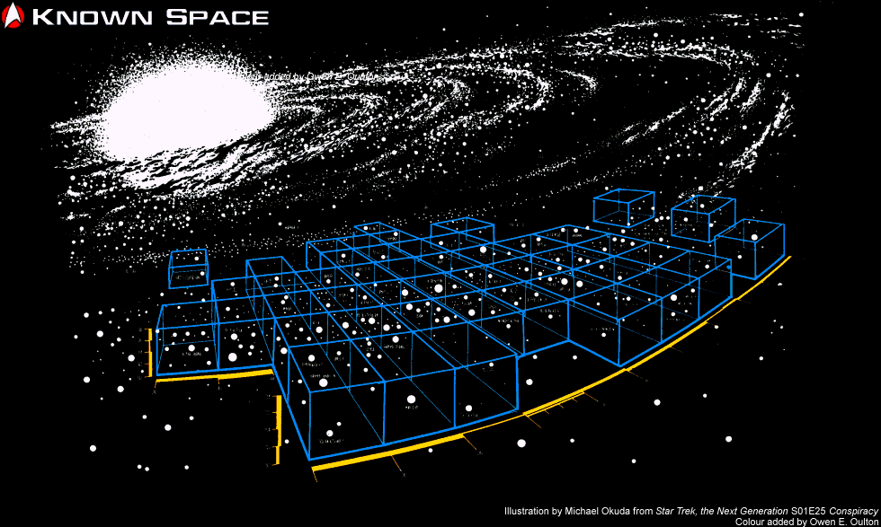
In stellar cartography, a sector, which was referred to as a star sector or space sector, is a gridded region within the Milky Way Galaxy. Sectors are composed of an area and volume encompassing several light years and typically contained several star systems. A group of sectors was called a sector block, which is located in a quadrant. The sector system and their numbering was used by United Earth, Vulcans, and other spacefaring races by the 22nd century. Most sectors are numbered, and in some cases, named after an important star system in that sector. In Federation nomenclature, the Sol system and Earth are located in Sector 001. Others were named after a key star system, such as the Mutara Sector. In other cases, they were given a designation consisting of both a name and number, such as Rhomboid Dronegar Sector 006. Sector 001 is the sector immediately to zenith of the point on the border between the Alpha and Beta Quadrants, 250Mly out from the supermassive black hole Sagittarius A* (Sgr A*) at the centre of the Milky Way Galaxy. This point is the Central Reference Point of Sector 000, the baseline of the entire mapping coordinate system for the United Federation of Planets.
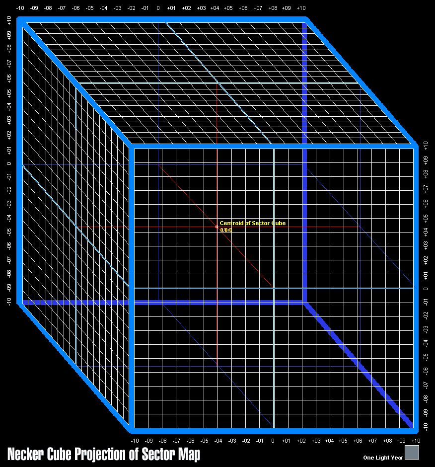
- The standard sector is defined as a cubic area of space 20ly on a side, comprising 8000 cubic light years. This distance was chosen due the fact that subspace radio typically has a range of approximately 20ly before the need of relay stations.


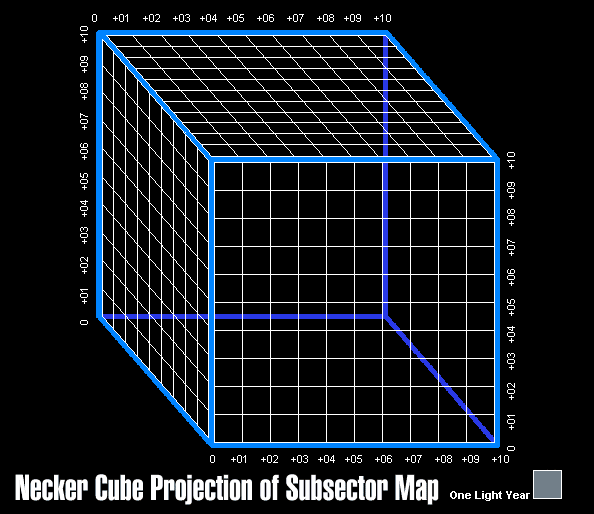
- Each sector is made up of eight octants (sometimes known as subsectors), each measuring 10ly on a side, comprising 1000 cubic light years. Octants are identified by the sector name followed by a Greek letter alpha through theta. Alpha (α) octant is the Rimward Trailing Zenith octant with beta (β) being the next one Spinward proceeding counter-clockwise through gamma (γ) and delta (δ). Epsilon (ε) octant is the Rimward Trailing Nadir octant proceeding counter-clockwise through eta (η), zeta (ζ) and theta (θ). Octants, or subsectors, are identified by the name of the sector followed by the Greek letter designator, such as Sector 000α and so on.
 Click on a tab below to view specific mapping data


|


